
Page 42 - Proceedings of The Fifth Meeting of Indigenous Medicine in the Mekong Basin
P. 42
36
COUNTRY PROFILE
Dr. Than Maung
Rector
University of Traditional Medicine
1. Location
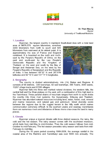
Myanmar, the largest country in mainland South-East Asia with a total land
area of M676,578 square kilometers, stretches
2200 kilometers from north to south and 925
kilometers from east-west at its widest point. It is
approximately the size of France and England
combined. It is bounded on the north and north-
east by the People's Republic of China, on the
east and south-east by the Lao People's
Democratic Republic and the Kingdom of
Thailand, on the west and south by the Bay of
Bengal and Andaman Sea, on the west by the
People's Republic of Bangladesh and the Republic
of India. It lies between 09°32' N and 28°31'N
latitudes and 92°10' E and 101°11' E longitudes.
2. Geography
The country is divided administratively, into (14) States and Regions. It
consists of 69 districts, 330 townships, 82 sub-townships, 396 Towns, 3045 wards,
13267 village tracts and 67285 villages.
Myanmar falls into three well marked natural divisions, the western hills, the
central belt and the Shan plateau on the east, with a continuation of this high land in
the Tanintharyi. Three parallel chains of mountain ranges from north to south divide
the country into three river systems, the Ayeyarwady, Sittaung and Thanlwin.
Myanmar has abundant natural resources including land, water, forest, coal, mineral
and marine resources, and natural gas and petroleum. Great diversity exists
between the regions due to the rugged terrain in the hilly north which makes
communication extremely difficult. In the southern plains and swampy marshlands
there are numerous rivers and tributaries of these rivers criss-cross the land in many
places.
3. Climate
Myanmar enjoys a tropical climate with three distinct seasons, the rainy, the
cold and the hot season. The rainy season comes with the southwest monsoon,
which lasts from mid-May to mid-October. Then the cold season follows from mid-
October to mid-February. The hot season precedes rainy season and lasts from mid-
February to mid-May.
During the 10 years period covering 1999-2008, the average rainfall in the
coastal area of the Rakhine and Tanintharyi was over 5000 mm annually. The